After a long spell of rain put paid to our plan for a weekend trip, a sudden stint of clear skies and light breeze made for the perfect day hike to Bhairavadurga. It is believed that Bhairavadurga Fort is one of the navadurgas (nine key forts) skirting the city of Bengaluru; the fort’s present condition unfortunately leaves much to be desired. These navadurgas comprise of the popularly known trio of Savandurga, Nandidurga and Devarayanadurga, and the rarely visited yet beautiful fort remains of Huliyurdurga, Hutridurga, Channarayandurga, Kabbaladurga, Makalidurga and Bhairavadurga. Bhairavadurga Fort was said to be built by Kempegowda and further fortified by Tipu Sultan; however, there aren’t any validated references we could find about this history.

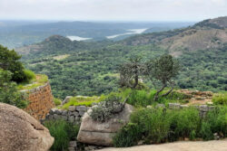
Bhairavadurga, as seen from the village of Kudur.
Not many know of the significance of these hills that are peppered around Bangalore – these form part of what is known as the Dharwar Craton, one of the oldest bedrocks in the world that make up peninsular India. Also known as Dharwar Rocks, these are named after the town of Dharwar; the discontinuous hills can easily be observed from some of the taller peaks around Bengaluru such as Skandagiri or Nandidurga. The word ‘craton’ stands for ‘strength’ in Greek and represents the crust of the earth that has remained largely unchanged for almost the entire life of this planet – over 3.5 billion years! To think that one is standing on top of the true origins of earth is an incredible feeling and part of the allure of exploring these hills.
Bhairavadurga hill is part of ‘Kuduru Major Forest’, but accessing it does not require special permissions, unlike some of the other hill forts like Kaiwara or Makalidurga, which also abut forest patches. As you get closer to Kudur village, one can see the towering hill with its steep gradients, which can seem quite daunting. We reached the base of the hill, or what Google pinned as the starting point of the trek, and had to pick between two routes – one with a fleet of stairs that led to the temple situated in the middle of the hill, and another, a rugged trail along the board of ‘Kudur Mini Forest’. We took the rugged path; stairs have never been our favourite.

A god/goddess (possibly Bhairava) sculpted on a rock at the base of the hill.

One of the steeper rock faces to be navigated.
Due to the recent Covid lockdown, the trail was overgrown with tall grass that was over 6 feet high in some places. These are interesting to observe – a single stalk carries a cluster of pins, and soft, crooked bristles. These bristles exhibit the unique behaviour of making themselves straight and stiff when wet, like a quirky magic trick. Why it does this is yet to be confirmed by scientists with certainty, but some posit that the bristles do this to maximise the absorption of water droplets into their base. The pins from the grass can be tricky, as they can get entangled inside one’s t-shirts and pants, and long after passing through, continue to prick unless pulled out meticulously.

A beetle perched on the grass stalk.
The hike up to the fort took us a little less than 2 hours – though the elevation itself is only about 1.2 km – largely due to the lack of a proper path, and with a few patches demanding some serious, four-limbed coordination. As with most hills around Bengaluru, apart from tall shrubs, Yellow Oleanders were a common sight along the trail until we reached the first wall of the fort. Yellow Oleander is poisonous and native to Central America, where it is widely used as an ornamental shrub; it baffles me why anything poisonous would ever be considered ornamental. During a study of these plants, it was found that in some of the South Indian villages, their seeds were the preferred means to die by suicide. Despite its ominous history, the Yellow Oleander looks beautiful, and I have noticed Purple Sunbirds feed off its flowers.

Dried scat of a small carnivore, as well as Yellow Oleander flowers, on the trek route.

A section of the trek which demanded sure-footed clambering.
As with all hill forts, crag martins, swifts and swallows flit around in vast numbers, and one can get a closer look at them from atop the fort. While navigating a tricky rocky patch, we managed to disturb a Jungle Fowl, which let its displeasure known as it scurried down the rock face. Black Drongos were also a common sight there, especially as they feed on the bountiful dragonflies and moths. We also spotted a Black Eagle surveying the horizon, soaring up the thermals (drafts of hot air that rise upward), using it to their advantage to hover while looking for prey, and thus conserving energy.

Colourful flowers (Asystasia sp.) standing out amongst the shrubs.
Unlike other isolated fort or temple hikes, the villagers do not use this hill to graze their herds, and one can spot hare scats in plenty. After a hunched walk through a short tunnel of thickets, one can spot the second fort wall that leads straight up to the final fort opening; here, three large boulders precariously lean onto each other, with the temple perched on top of one of them. Today, there is only a graft in the boulder where a ladder once stood, so unless you are a serious rock climber, reaching the temple is extremely difficult.

A path through thickets.

The temple atop the hill.
Some online sleuthing indicates that there used to be a citadel on top with granaries and a water tank, but there isn’t much left of these today. One can barely identify the fort wall, as these are more or less masked by shrubs and grass. We did spot the remnants of what seemed to be the base of a pillar base; sadly, these precious monuments are dilapidated and need immediate preservation before they fade into just another hill top. All we stumbled upon was a single slab of rock bearing sculpted poses of either Vishnu or Hanuman.
By the time we reached the summit, the cool and breezy weather had turned quite searing, and we regretted not having started earlier in the day. Several photo ops later, after soaking in the views of the plush landscape, we made our way down, once again scrambling and occasionally losing our way. Despite this, the walk down took about 40 minutes. All in all, it was a day well spent making good use of the weather and our legs, reflecting on what lay ahead in these uncertain times.
Getting There:
Drive from Bengaluru to Kudur Village via Nelamangala. Google Maps is fairly accurate, so a search for ‘Bhairavadurga Fort’ will get you to the base of the hill. The hill will appear to your right as you reach the destination.
Tips:
Wear full sleeved t-shirts and long pants, as the path can get quite thorny with tall shrubs. Wearing shorts isn’t recommended.


Instagram
junglelodgesjlr